Super Typhoon Pepito (I.N. Manyi)
Situation Report
November 16, 2024
11:00 PM

Situation Overview
In the evening of November 14, 2024, Severe Tropical Storm with international name Manyi entered the Philippine Area of Responsibility (PAR) and was given the local name Pepito. Philippine Atmospheric, Geophysical and Astronomical Services Administration (PAGASA) reported that it has maximum sustained winds of 100 km/hour and gustiness of up to 125 km/hour. It was moving westward at 35 km/hour. Tropical Cyclone Wind Signal (TCWS) no. 1 was raised in Catanduanes, the eastern portion of Camarines Sur, the eastern portion of Albay, the eastern and southern portions of Sorsogon, Northern Samar, the northern portion of Eastern Samar, and the northeastern portion of Samar.
On November 15, it further intensified nearing typhoon category as it moved westward at 25 km/hour with maximum sustained winds of 110 km/hour and gustiness of up to 135 km/hour. The eastern portion of Camarines Norte was added to the areas where TCWS no. 1 was in effect. At the 11AM bulletin of PAGASA, Pepito underwent rapid intensification and intensified into a typhoon with a maximum sustained winds of 130 km/hour and gustiness of up to 160 km/hour. TCWS no. 2 was raised in the eastern portion of Northern Samar, and the northern portion of Eastern Samar. TCWS no. 1 was in effect in the southeastern portion of Quezon, Camarines Norte, Camarines Sur, Catanduanes, Albay, Sorsogon, Masbate, the rest of Northern Samar, the rest of Eastern Samar, Samar, and Biliran. It further intensified rapidly putting more areas under TCWS no. 2 such as the northeastern portion of Samar and under TCWS no. 1 such as Aurora, the eastern portion of Laguna, and Marinduque. It has maximum sustained winds of 150 km/hour and gustiness of up to 185 km/hour. At the 11PM PAGASA bulletin, it continued to intensify moving west northwestward at 25 km/hour with maximum sustained winds of 155 km/hour and gustiness of up to 190 km/hour. TCWS no. was hoisted over the northern and eastern portions of Camarines Sur, Catanduanes, the eastern portion of Albay, the eastern portion of Sorsogon, the northern and easter portions of Northern Samar, the northern portion of Eastern Samar, and the northeastern portion of Samar. TCWS no. 1 was placed in the southern and eastern portions of Isabela, Quirino, the eastern and southern portions of Nueva Vizcaya, Aurora, the eastern portion of Nueva Ecija, the eastern portion of Bulacan, Metro Manila, Laguna, Rizal, Quezon including Polillo Islands, Marinduque, Camarines Norte, the rest of Camarines Sur, the rest of Albay, the rest of Sorsogon, Masbate including Burias and Ticao Islands, the rest of Northern Samar, the rest of Eastern Samar, the rest of Samar, Biliran, and the northeastern portion of Leyte.
On November 16, Typhoon Pepito was nearing the super typhoon category as it moved west northwestward at 25 km/hour, threatening Southern Luzon and Eastern Visayas. It has maximum sustained winds of 175 km/hour and gustiness of up to 215 km/hour. TCWS no. 3 was raised in Catanduanes, the eastern portion of Albay, the eastern portion of Camarines Sur, the easternmost portion of Sorsogon, the eastern portion of Northern Samar, and the northernmost portion of Eastern Samar. TCWS no. 2 was in effect in the rest Camarines Sur, the rest of Albay, the rest of Sorsogon, Ticao Islands, Camarines Norte, the easternmost portion of mainland Quezon, Polillo Islands, the northern portion of Eastern Samar, the northern portion of Samar, and the rest of Northern Samar. TCWS no. 1 was placed in the rest of Masbate including Burias Island, Marinduque, Romblon, the rest of CALABARZON (Cavite, Laguna, Batangas, Rizal, Quezon), Metro Manila, Central Luzon (Aurora, Bataan, Bulacan, Nueva Ecija, Pampanga, Tarlac, Zambales), Quirino, Nueva Vizcaya, Isabela, the central and southern portions of Cagayan, Pangasinan, La Union, Ilocos Sur, Abra, the southern portion of Apayao, Kalinga, Mountain Province, Ifugao, Benguet, the rest of Eastern Samar, the rest of Samar, Biliran, the northern and central portions of Leyte, the northeastern portion of Southern Leyte, the northernmost portion of Cebu including Bantayan Islands, the northernmost portion of Iloilo, and the northern portion of Dinagat Islands. At the 11AM PAGASA bulletin, Pepito intensified into a super typhoon with maximum sustained winds of 185 km/hour and gustiness of up to 230 km/hour. Catanduanes and the northeastern portion of Camarines Sur were placed under TCWS no. 4 while the eastern portion of Camarines Norte, the northern and southeastern portion of Camarines Sur, the eastern portion of Albay, the northeastern portion of Sorsogon, the eastern portion of Northern Samar, and the northern portion of Eastern Samar were placed under TCWS no. 3. TCWS no. 2 was hoisted over the southeastern portion of Isabela, Aurora, Quezon, the eastern portion of Rizal, Laguna, the rest of Camarines Norte, Camarines Sur, Albay, and Sorsogon, Ticao Island, the central portion of Eastern Samar, the northern portion of Samar, and the rest of Northern Samar. TCWS no. 1 was in effect in Mainland Cagayan, the rest of Isabela, Quirino, Nueva Vizcaya, Apayao, Kalinga, Abra, Mountain Province, Ifugao, Benguet, the Ilocos Region, Nueva Ecija, Bulacan, Tarlac, Pampanga, Zambales, Bataan, Metro Manila, the rest of Rizal, Cavite, Batangas, Marinduque, the northern portion of Oriental Mindoro, Romblon, the rest of Masbate, the rest of Eastern Samar, the rest of Samar, Biliran, the northern and central portions of Leyte, the northeastern portion of Southern Leyte, the northernmost portion of Cebu including Bantayan Islands, the northernmost portion of Iloilo, and northern portion of Dinagat Islands. At the 2PM bulletin, Super Typhoon further intensified with maximum sustained winds of 195 km/hour and gustiness of up to 240 km/hour. Catanduanes was placed in TCWS no. 5.

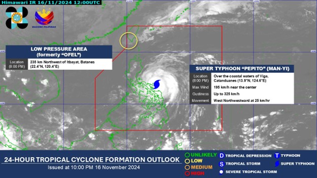
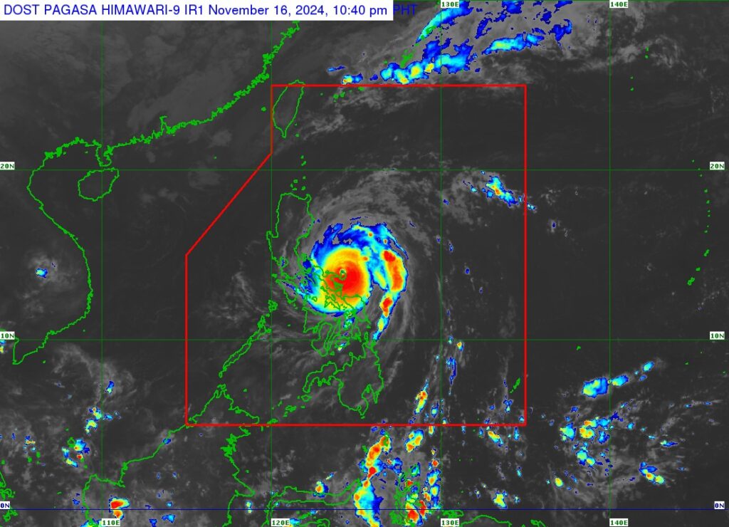
At 9:40PM on November 16, Super Typhoon Ofel made landfall in the vicinity of Panganiban, Catanduanes. It reached the maximum sustained winds of 195 km/hour and gustiness of up to 325 km/hour. TCWS no. 5 was raised in Catanduanes and the northeastern portion of Camarines Sur. TCWS no. 4 was placed in the northeastern portion of Albay, the eastern portion of Camarines Sur, Camarines Norte, and Polillo Islands. TCWS no. 3 was hoisted over the northern portion of Sorsogon, the rest of Albay, the rest of Camarines Sur, the northeastern portion of Quezon, the eastern portion of Laguna, the eastern and central portions of Rizal, Aurora, the northern and eastern portions of Bulacan, the northeastern portion of Pampanga, the eastern portion of Tarlac, Nueva Ecija, the eastern portion of Pangasinan, Nueva Vizcaya, Quirino, and the southernmost portion of Isabela. TCWS no. 2 was in effect in the rest of Sorsogon, Ticao Island, Burias Island, Marinduque, the rest of Quezon, the rest of Laguna, the rest of Rizal, Cavite, the northern portion of Batangas, Metro Manila, Bataan, Zambales, the rest of Tarlac, the rest of Pampanga, the rest of Bulacan, Kalinga, Abra, Mountain Province, Ifugao, Benguet, the southern portion of Apayao, Ilocos Sur, La Union, the rest of Pangasinan, the rest of Isabela, the southwestern portion of Cagayan, Northern Samar, the northern portion of Samar, and the northern portion of Eastern Samar. TCWS no. 1 was placed in the rest of Masbate, Romblon, the rest of Batangas, the rest of mainland Cagayan, the rest of Apayao, Ilocos Norte, the northern and central portions of Oriental Mindoro, the northern and central portions of Occidental Mindoro including Lubang Islands, the central portion of Samar, the central portion of Eastern Samar, Biliran, the northern portion of Leyte, the northernmost portion of Cebu including Bantayan Islands, and the northernmost portion of Iloilo.
Source: PAG-ASA
Affected Populations
National Disaster Risk Reduction and Management Council (NDRRMC) reported combined effects of Typhoons Nika and Ofel, and Super Typhoon Pepito. A total of 234,058 families or 833,982 people were affected in 5 regions. 481,324 were pre-emptively evacuated from the Ilocos Region, Cagayan Valley, Central Luzon, CALABARZON, and Bicol Region. 112,191 people were displaced where 76,269 individuals were served inside 586 evacuation centers.
In the morning of November 16, hours before Super Typhoon made landfall in Catanduanes, coastal municipalities in the Bicol Region such as Virac in Catanduanes, Tiwi and Legazpi in Albay, and Camarines Sur experienced storm surge that caused flooding. while Catholic churches in Sorsogon and Catanduanes opened its doors to evacuees. An organization in Bicol also reported 363,271 people from 18 municipalities in Albay evacuated. 9,228 people in Caramoan and 3,664 people in Lagonoy in Camarines Sur also evacuated ahead of the onslaught of Super Typhoon Pepito in the Bicol Region.
Sources: NDRRMC, KMP Bicol, Inquirer, Philippine Star, Rappler
Emergency Response Efforts
- CDRC along with the affected regional partners, continues to monitor the situation and has commenced issuing situation reports.
- Regional partners initiate call for support for their communities affected by the super typhoon.
Resources Available
- Standby emergency funds
- Prepositioned goods at the CDRC Warehouse
- Monetary and in-kind donations
Expressed Needs
- Relief food packs
- Shelter repair kit
- Hygiene kits
- Over the counter medicines
Coordination
- Regional Partners
- People’s Organizations
Contacts
- Rosalia “Ross” Singcol – 09854359628
- Glenn Latoza – 09662343358
