 Typhoon Marce (I.N. Yinxing)
Situation Report
November 9, 2024
8:00 pm
On November 4, 2024, Marce entered the Philippine Area of Responsibility (PAR) as Tropical Storm Marce. It has maximum sustained winds of up to 65 km/hour near the center and gustiness of up to 80 km/hour. It was moving west northwestward at 25 km/hour. At 11 PM of the same day, it intensified into a Severe Tropical Storm as it underwent rapid intensification with maximum sustained winds of 100 km/hour and gustiness of up to 125 km/hour. Tropical Cyclone Wind Signal (TCWS) no. 1 was hoisted over Batanes, the northern and eastern portions of Cagayan including Babuyan Islands, the eastern portion of Isabela, the northern portion of Apayao, and the northern portion of Ilocos Norte.
By 11AM of November 5, Marce intensified into a Typhoon moving west northwestward at 30 km/hour with maximum sustained winds of 120 km/hour and gustiness of up to 150 km/hour. Philippine Atmospheric, Geophysical and Astronomical Services Administration (PAGASA) raised TCWS no. 1 in 12 areas including Batanes, Cagayan including Babuyan Islands, Isabela, Ilocos Norte, Apayao, Abra, Kalinga, Mountain Province, Ifugao, the northern portion of Nueva Vizcaya, the northern portion of Quirino, and the northern portion of Aurora. It further intensified raising the TCWS no. 2 in the northeastern portion of mainland Cagayan affecting the municipalities of Santa Ana and Gonzaga by 11PM. 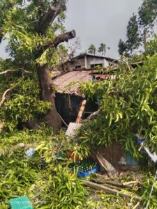
On November 6 at the 8AM forecast of the weather bureau, it was reported that Typhoon Marce slightly decelerated but still intensified over the Philippine Sea east of Northern Luzon. It was moving westward slowly with maximum sustained winds of 140 km/hour
and gustiness of up to 170 km/hour. TCWS no. 2 was in effect in the eastern portion of Babuyan Islands and the northeastern portion of mainland Cagayan affecting eight of its municipalities. TCWS no. 1 was hoisted over Batanes, the rest of Babuyan Islands, the rest of mainland Cagayan, Ilocos Norte, Ilocos Sur, Apayao, Abra, Kalinga, Mountain Province, Ifugao, the northern portion of Benguet, Isabela, Nueva Vizcaya, Quirino, and the northern portion of Aurora. By 11AM, Santa Ana, Cagayan was under TCWS no. 3, bringing a maximum sustained winds of 150 km/hour and gustiness of up to 185 km/hour. By 2PM, the municipalities of Santa Ana and Gonzaga in Cagayan was under TCWS no. 3. The typhoon started to become stationary over the waters east of Northern Cagayan as reported at 5PM. It continued to threaten 17 municipalities in mainland Cagayan, the southern portion of Babuyan Islands, and the eastern portion of Apayao as issued in the 8PM bulletin of PAGASA. By 11PM, it further intensified moving west northwestward at 10 km/hour with maximum sustained winds of 155 km/hour and gustiness of up to 190 km/hour. TCWS no. 3 was in effect in the northern and central portions of mainland Cagayan including Babuyan Islands, and the eastern portion of Apayao. TCWS no. 2 was hoisted over Batanes, the rest of mainland Cagayan, the northern and central portions of Isabela, the rest of Apayao, Abra, Kalinga, the eastern and central portions of Mountain Province, Ilocos Norte, and the northern portion of Ilococ Sur. TCWS no. 1 was in effect in the rest of Ilocos Sur, La Union, the northern portion of Pangasinan, the rest of Mountain Province, Ifugao, Benguet, the rest of Isabela, Quirino, Nueva Vizcaya, the northern and central portions of Aurora, and the northern portion of Nueva Ecija.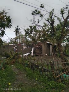
At the November 7 2AM bulletin of PAGASA, Typhoon Marce maintained its strength as it accelerated toward the northern portion of Mainland Cagayan and the Babuyan Islands. By this time, 7 municipalities in the northeastern portion of mainland Cagayan and the Camiguin Island were under TCWS no. 4. It slightly intensified as it moved west northwestward slowly with maximum sustained winds of 165 km/hour and gustiness of up to 205 km/hour. TCWS no. 4 was in effect in the northern portion of mainland Cagayan including Babuyan Islands, the northeastern portion of Apayao, and in Pagudpod, Ilocos Norte. By 11AM, it further intensified reaching the maximum sustained winds of 175 km/hour and gustiness of up to 215 km/hour. It was approaching the northeastern part of Cagayan dangerously. At 3:40PM, it made its first landfall in Santa Ana, Cagayan with maximum sustained winds of 175 km/hour and gustiness of up to 240 km/hour. TCWS No. 4 was hoisted over the northern portion of Cagayan including Babuyan Islands, the northern portion of Apayao, and the northern portion of Ilocos Norte. TCWS No. 3 was in effect in Batanes, the rest of Cagayan, the rest of Apayao, the rest of Ilocos Norte, the northern portion of Abra, and the northern portion of Ilocos Sur. TCWS no. 2 was hoisted over the northern and central portions of Isabela, the rest of Abra, Kalinga, Mountain Province, the northern portion of Ifugao, the rest of Ilocos Sur, and the northern portion of La Union. TCWS no. 1 was in effect in the rest of La union, Pangasinan, the rest of Ifugao, the rest of Benguet, the rest of Isabela, Quirino, Nueva Vizcaya, the northern and central portions of Aurora, the northern portion of Nueva Ecija, and the northern portion of Zambales. At 9PM, it made its second landfall in Sanchez-Mira, Cagayan.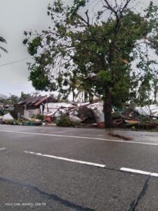
On November 8 by 2AM, life-threatening conditions persisted over the northern portions of Cagayan, Apayao, and Ilocos Norte as it moved west southwestward at 20 km/hour with maximum sustained winds of 165 km/hour and gustiness of up to 275 km/hour. TCWS no. 4 was in effect in the northwestern portion of Cagayan including Babuyan Islands, northern portion of Apayao, the northernmost portion of Abra, Ilocos Norte, and the northernmost portion of Ilocos Sur.
It started to weaken until it exited PAR by 4PM of November 8.
Sources: PAG-ASA, NDRRMC
Affected Population
According to the National Disaster Risk Reduction and Management Office (NDRRMO), as of November 9 at 8PM, a total of 57,745 families or 197,767 individuals have been affected across 3 regions. Of which, 19,960 individuals have been served inside 333 evacuation centers and 11,456 have been served outside evacuation centers. A total of 11,858 families or 34,501 individuals were pre-emptively evacuated.
No fatalities were reported however, one (1) was injured and one (1) was reported to be missing in the Ilocos Region. 47 road sections and 27 bridges were affected by the onslaught of Typhoon Marce. 33 road sections out of 47 and 25 bridges out of 27 are still not passable. A total of 60 cities/municipalities reported power interruption where 13 are already restored. 7 cities/municipalities reported communication lines were down where only 2 is restored. 12 seaports in the Cagayan Valley were reported to be non-operational.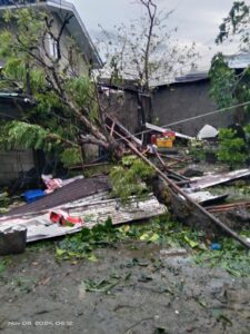
Due to the high-speed wind brought by Typhoon Marce, a total of 14,190 houses have been reported to be damaged. 13,236 were partially damaged and 954 were totally damaged. 12,969 out of the total partially damaged were reported in Cagayan Valley while 949 out of 954 totally damaged houses were reported in the same region. 49 infrastructures have been damaged where estimated cost of the damage amounts to PHP 25,398,600.
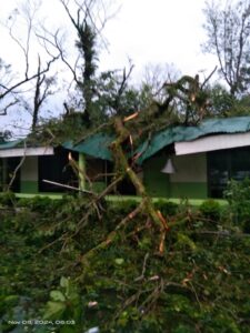
34 areas in Cagayan Valley have been flooded. Likewise, 3 areas in Cagayan have been devastated by rain-induced landslide. As Santa Ana, Cagayan faced the strong winds brought by Typhoon Marce, bridges were reported to be submerged, and roads were flooded. Even the municipal police station was not spared as the building was battered by the strong winds, scattering debris all over its vicinity. Houses and other establishments were damaged by the high-speed and strong winds. Trees and electric posts were toppled. Gonzaga, Cagayan reported damage to its town hall as its glass door shattered. Lal-lo, Cagayan also reported flooding and toppling of electric posts. In Aparri, Cagayan, the typhoon toppled houses, scattered roofing, and damaged fishing boats. Cagayan Provincial Information Office reported the destruction of roof system of Buguey North Central School due to strong winds brought by Typhoon Marce. In Abulug, Cagayan, more than 3,000 houses were reported to be damaged. Lucban Elementary School located in Abulug was not saved from the onslaught of Typhoon Marce. Trees were toppled and some even fell over the roof system.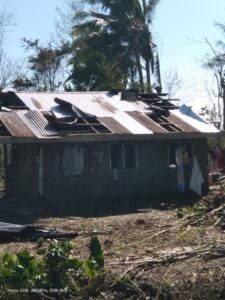
The country has not yet recovered from the devastation of Severe Tropical Storm Kristine, Typhoon Leon, and the recent Typhoon Marce still, another tropical cyclone has developed inside PAR today.
Source: National Disaster Risk Reduction Management and Council (NDRRMC), Inquirer, Cagayan PIO, PAGASA
Emergency Response Efforts
- CDRC along with the affected regional partners, continues to monitor the situation and has commenced issuing situation reports.
- Friends of CDRC facilitates call for support for the individuals affected by Typhoon Marce.
Resources Available
- Standby emergency funds
- Monetary and in-kind donations
Expressed Needs
- Immediate Shelter Repair Kit
- Hygiene Kits
- Over the counter medicines
Coordination
- Regional Partners
- People’s Organizations
- 17 member organizations of the Citizens’ Disaster Response Network (CDRN) nationwide
Contacts
- Rosalia “Ross” Singcol, Deputy Executive Director – rosssingcol@gmail.com – 09854359628
- Glenn Latoza, Field Operations Department Head – fod.cdrc1984@gmail.com – 09662343358
IN PHOTOS: Aftermath of Typhoon Marce in Abulug Cagayan.
📷Nazario Rodriguez
